

The Washington monument
February 22nd
1855 – The U.S. Congress voted to appropriate $200,000 for continuance of the work on the Washington Monument. The next morning the resolution was tabled and it would be 21 years before the Congress would vote on funds again. Work was continued by the Know-Nothing Party in charge of the project.
1859 – U.S. President Buchanan approved the Act of February 22, 1859, which incorporated the Washington National Monument Society “for the purpose of completing the erection now in progress of a great National Monument to the memory of Washington at the seat of the Federal Government.”
1885 – The Washington Monument was officially dedicated in Washington, DC. It opened to the public in 1889.
on-this-day.com
Share this:

History… February 22

1630 – Quadequine introduced popcorn to English colonists at their first Thanksgiving dinner.
1784 – “Empress of China”, a U.S. merchant ship, left New York City for the Far East.
1819 – Spain ceded Florida to the United States.
1855 – The U.S. Congress voted to appropriate $200,000 for continuance of the work on the Washington Monument. The next morning the resolution was tabled and it would be 21 years before the Congress would vote on funds again. Work was continued by the Know-Nothing Party in charge of the project.
1859 – U.S. President Buchanan approved the Act of February 22, 1859, which incorporated the Washington National Monument Society “for the purpose of completing the erection now in progress of a great National Monument to the memory of Washington at the seat of the Federal Government.”
1860 – Organized baseball’s first game was played in San Francisco, CA.
1865 – In the U.S., Tennessee adopted a new constitution that abolished slavery.
1879 – In Utica, NY, Frank W. Woolworth opened his first 5 and 10-cent store.
1885 – The Washington Monument was officially dedicated in Washington, DC. It opened to the public in 1889.
1892 – “Lady Windermere’s Fan”, by Oscar Wilde, was first performed.
1920 – The first dog race track to use an imitation rabbit opened in Emeryville, CA.
1923 – The first successful chinchilla farm opened in Los Angeles, CA. It was the first farm of its kind in the U.S.
1924 – U.S. President Calvin Coolidge delivered the first presidential radio broadcast from the White House.
1954 – ABC radio’s popular “Breakfast Club” program was simulcast on TV for the first time.
1969 – Barbara Jo Rubin became the first woman to win a U.S. thoroughbred horse race.
1973 – The U.S. and Communist China agreed to establish liaison offices.
1984 – The U.S. Census Bureau statistics showed that the state of Alaska was the fastest growing state of the decade with an increase in population of 19.2 percent.
1994 – The U.S. Justice Department charged Aldrich Ames and his wife with selling national secrets to the Soviet Union. Ames was later convicted to life in prison. Ames’ wife received a 5-year prison term.
1997 – Scottish scientist Ian Wilmut and colleagues announced that an adult sheep had been successfully cloned. Dolly was actually born on July 5, 1996. Dolly was the first mammal to have been successfully cloned from an adult cell.
2002 – In the Philippines, An MH-47E Chinook helicopter crashed into the ocean. All 10 men aboard were killed.
2010 – A copy of “Action Comics #1” sold at auction for $1 million. The comic featured the introduction of Superman.
2010 – Walmart announced it was acquiring the video streaming company Vudu, Inc.
on-this-day.com
Share this:

A Picture Worth a Thousand More …Lonnie G. Bunch at The NMAAHC- Black History
a repost … 2011
Lonnie Bunch, museum director, historian, lecturer, and author, is proud to present A Page from Our American Story, a regular on-line series for Museum supporters. It will showcase individuals and events in the African American experience, placing these stories in the context of a larger story — our American story


Few things date history as readily as fashion. The caveat “that was the fashion of the times” can be applied to everything from bustles and corsets to micro-mini skirts and polyester pants suits — fashions at the turn of the twentieth century and styles created during the 1960s-’70s.
While designs have changed over the years, one thing remained the same: from department store catalogs to high-end fashion magazines, the models dressed in the latest fashions were white.
So it was a major event when Katiti Kironde appeared in the August 1968 issue of Glamour College, the first African American to appear on a American fashion magazine’s cover. Six years later, in August 1974, Beverly Johnson became the first African American woman featured on the cover of Vogue magazine — the industry’s supreme publication. It was another landmark.
Like virtually everything else on the path to equal opportunity for African Americans, progress was slow and came in steps, not leaps. So when an African American woman first appeared in one of the fashion industry’s premier magazines, it was not on a cover or with a huge, multi-page layout.
Instead, seven years before Kironde’s Glamour cover, a coed at the University of California at Los Angeles (UCLA), Willette Murphy, quietly appeared on the pages of the August 1961 issue of another hugely popular magazine, Mademoiselle.
Murphy, now Willette Klausner, was pictured wearing a simple skirt, top and jacket, and walking on the UCLA campus. Initially, she viewed the moment as “just another thing I’d done.”

Far from it: Willette Murphy’s appearance in the magazine was not merely “just another thing.” Her Mademoiselle photograph was groundbreaking. Yet, Murphy was unaware of her place in history, until a New York Times’ reporter contacted her family. “I guess my sister found out when the New York Times called my parents,” Klausner said in a published interview.
Her family was used to Willette achieving things African Americans rarely experienced at that time — she was UCLA’s first black senior class president, for example — but the call from the Times made the family realize that their daughter had made history.
For decades, in high powered fashion magazines like Vogue, Glamour and Mademoiselle, to the Sears and Roebuck and other mail order catalogs, to models walking runways in Paris and New York, the face of fashion had been white.
Images of African Americans were scarce even in popular, mainstream American magazines. Many white Americans were shocked when Dorothy Dandridge became the first African American female to appear on the cover of LIFE in November, 1954. It would be nearly four years later before another black American, boxer Sugar Ray Robinson, would find his way onto that magazine’s front page. Another African American female celebrity would not grace LIFE’s cover again until the December 8, 1967 issue which featured Pearl Bailey.
Imagine growing up black and female and seeing dress after dress, swimsuit after swimsuit, shoe after shoe — all pictured only on white women. Along with every other message sent to African Americans, this underscored the sense that African Americans were, to a great degree, nonexistent — even when it came to buying clothes.
Today fashion marketers, like marketers from every other industry, recognize that the face of America is as diverse as its people. They also recognize that African Americans’ buying power was estimated at $913 billion in 2009. A University of Georgia economics study projects that figure will rise to $1.2 trillion in 2013 — nearly 9% of the country’s estimated purchasing strength.
Today the power of the African American pocketbook is reflected on the covers of countless magazines — fashion, entertainment, and political publications which routinely feature black models, entertainers, authors, politicians and more.
 Photo Courtesy of Ms. Klausner |
Today, it is no longer shocking to walk into a supermarket and find an African American on a magazine cover. In March 2009, First Lady Michelle Obama appeared on the cover of Vogue, only the second first lady to do so. In recent years Vogue has seen a number of black women grace its cover.
Sometimes history is made in giant leaps. More often, however, it is made in smaller, sometimes unexpected steps. Willette Murphy Klausner would become the first black merchandising executive at Bloomingdale’s, later the first female corporate vice president at MCA Universal Studios and, together with Julia Child and Robert Mondavi, the co-founder of the American Institute of Wine and Food in 1981. Today, she is a successful theater producer.
It is her photo in Mademoiselle that we celebrate today. A picture that would launch thousands more.

|
|||||
| P.S. We can only reach our $250 million goal with your help. I hope you will consider making a donation or becoming a Charter Member today. | |||||
Share this:

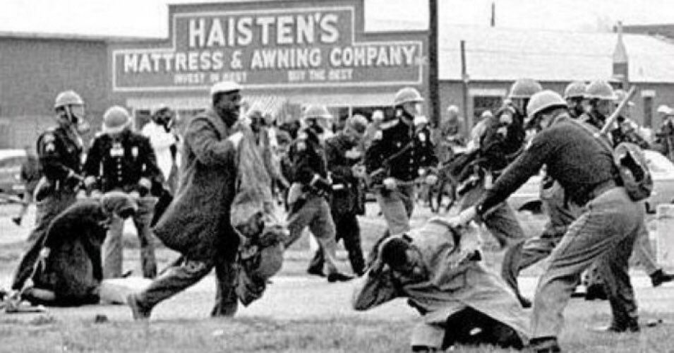
rep John Lewis – In Memory

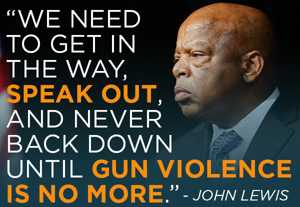
2020 Body of civil rights activist John Lewis crosses the Edmund Pettus Bridge in Selma for the last time (beaten there 55 years ago) with a military honor guard as part of a remembrance ceremony
onthisday.com


You must be logged in to post a comment.